Property Record
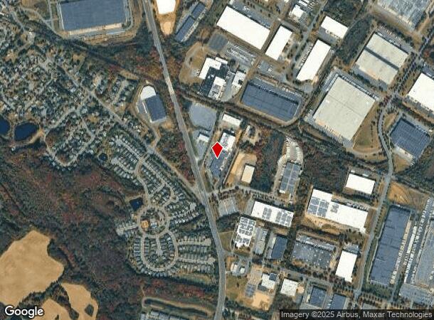
2400 Us Rte 130 Rte, Dayton, NJ 08810
NEARBY LISTINGS FOR SALE OR LEASE
Property Detail
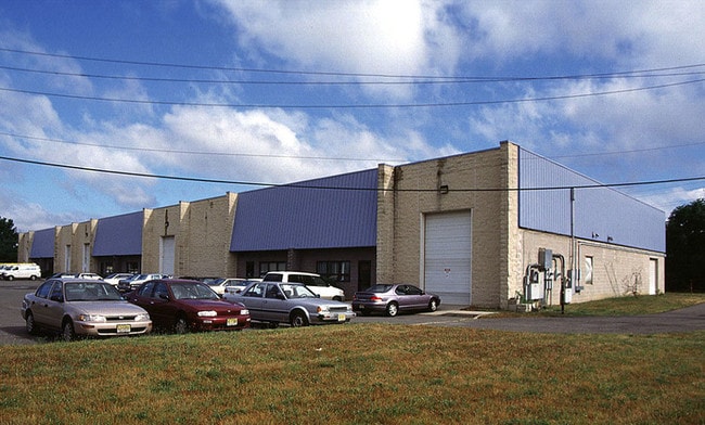
2400 Us Rte 130 Rte
New York-Jersey City-White Plains, NY-NJ
6.67 AC 93-99.6K SF OFF/WHS. BUILT 1990 SOLAR. 8600SF MEZ
21-00012-03-00011-07
Middlesex
Warehouse
New Jersey
X
11.7
34023C0251F
6.67 AC
2023
Exit 8A
2024
Northern New Jersey
008505
DEMOGRAPHICS near 2400 Us Rte 130 Rte
1 Mile
3 Mile
5 Mile
2024 Total Population
2,507
25,116
103,606
2029 Population
2,489
25,022
103,199
Pop Growth 2024-2029
(0.72%)
(0.37%)
(0.39%)
Average Age
41
44
43
2024 Total Households
801
9,449
39,579
HH Growth 2024-2029
(0.75%)
(0.77%)
(0.75%)
Median Household Inc
$160,092
$117,866
$113,631
Avg Household Size
3.00
2.60
2.60
2024 Avg HH Vehicles
2.00
2.00
2.00
Median Home Value
$590,065
$411,207
$453,795
Median Year Built
1996
1987
1987
Nearby Places
Map Layers
Map Styles
 Street
 Aerial
- Restaurants
- Banks
- Shops
- Fitness
- Groceries
PUBLIC TRANSPORTATION
COMMUTER RAIL
Jersey Avenue (Northeast Corridor Line - NJ Transit Commuter Rail (NJ Transit))
DRIVE
WALK
Distance
Jersey Avenue (Northeast Corridor Line - NJ Transit Commuter Rail (NJ Transit))
21 min
9.8 mi
AIRPORT
Trenton Mercer
DRIVE
WALK
Distance
Trenton Mercer
36 min
23.2 mi
Newark Liberty International
DRIVE
WALK
Distance
Newark Liberty International
51 min
37.3 mi
Freight Ports
New York Container Terminal
DRIVE
WALK
Distance
New York Container Terminal
45 min
32.4 mi
Nearby Properties
Address
Land Use
TOTAL SIZE
Lot Size
Zoning
Address
Land Use
TOTAL SIZE
Lot Size
Zoning
161,447 SF
67.62 AC
R30
Address
Land Use
TOTAL SIZE
Lot Size
Zoning
212.16 AC
I-3
Address
Land Use
TOTAL SIZE
Lot Size
Zoning
42.10 AC
LI5
Address
Land Use
TOTAL SIZE
Lot Size
Zoning
1,154,372 SF
167.04 AC
LI
Address
Land Use
TOTAL SIZE
Lot Size
Zoning
1,145,608 SF
73.19 AC
LI
Address
Land Use
TOTAL SIZE
Lot Size
Zoning
80.34 AC
LI5
Address
Land Use
TOTAL SIZE
Lot Size
Zoning
983,940 SF
62.53 AC
LI
Address
Land Use
TOTAL SIZE
Lot Size
Zoning
58.21 AC
LI
Address
Land Use
TOTAL SIZE
Lot Size
Zoning
29,951 SF
55.65 AC
R20
Address
Land Use
TOTAL SIZE
Lot Size
Zoning
74.64 AC
LI
Address
Land Use
TOTAL SIZE
Lot Size
Zoning
51.28 AC
LI
Address
Land Use
TOTAL SIZE
Lot Size
Zoning
87.65 AC
LI-4
Address
Land Use
TOTAL SIZE
Lot Size
Zoning
0.46 AC
AH
Address
Land Use
TOTAL SIZE
Lot Size
Zoning
528,314 SF
31.98 AC
LI
Address
Land Use
TOTAL SIZE
Lot Size
Zoning
28,155 SF
90.95 AC
I3R4
Address
Land Use
TOTAL SIZE
Lot Size
Zoning
72.62 AC
PL
Address
Land Use
TOTAL SIZE
Lot Size
Zoning
38.20 AC
LI
Address
Land Use
TOTAL SIZE
Lot Size
Zoning
29.74 AC
R30
Address
Land Use
TOTAL SIZE
Lot Size
Zoning
79.67 AC
I-3
Address
Land Use
TOTAL SIZE
Lot Size
Zoning
38.99 AC
LI
Address
Land Use
TOTAL SIZE
Lot Size
Zoning
50.73 AC
I-3
Address
Land Use
TOTAL SIZE
Lot Size
Zoning
31.12 AC
LI
Address
Land Use
TOTAL SIZE
Lot Size
Zoning
18.93 AC
R30
Address
Land Use
TOTAL SIZE
Lot Size
Zoning
18.24 AC
ROLI
Address
Land Use
TOTAL SIZE
Lot Size
Zoning
44.80 AC
LI-4
Address
Land Use
TOTAL SIZE
Lot Size
Zoning
49.12 AC
LI-4
Address
Land Use
TOTAL SIZE
Lot Size
Zoning
31.52 AC
LI
Address
Land Use
TOTAL SIZE
Lot Size
Zoning
3,555 SF
25.73 AC
PL
Address
Land Use
TOTAL SIZE
Lot Size
Zoning
16.13 AC
ROLI
Address
Land Use
TOTAL SIZE
Lot Size
Zoning
11.09 AC
ROLI
The World's #1 Commercial Real Estate Marketplace
Connect with us
© 2025 CoStar Group
The information above has been obtained from sources believed reliable. While we do not doubt its accuracy we have not verified it and make no guarantee, warranty or representation about it. It is your responsibility to independently confirm its accuracy and completeness. Any projections, opinions, assumptions, or estimates used are for example only and do not represent the current or future performance of the property. The value of this transaction to you depends on tax and other factors which should be evaluated by your tax, financial, and legal advisors. You and your advisors should conduct a careful, independent investigation of the property to determine to your satisfaction the suitability of the property for your needs.